Sinai is a triangular peninsula in Egypt that connects the continents of Africa and Asia. Covering an area of about 60,000 square kilometers, it is bounded by the Mediterranean Sea to the north, the Red Sea to the south, and the Gulf of Aqaba to the east. The Suez Canal and the Gulf of Suez lie to the west, making it a crucial geographical and strategic location.
History of Sinai :
Sinai Peninsula has been a crossroads for ancient civilizations, including Egyptians, Israelites, and Nabateans. It is often associated with biblical events, most notably Mount Sinai, where Moses is said to have received the Ten Commandments. The peninsula was the site of the ancient trade route known as the Way of Horus.
Sinai’s geography
is diverse, featuring arid deserts, rugged mountains, and coastal plains. The southern part of the peninsula is dominated by the high mountain ranges, including Mount Catherine, Egypt’s highest peak at 2,629 meters. The northern part is characterized by vast desert expanses.
The climate in Sinai: varies from arid in the north to semi-arid in the south, with significant temperature differences between day and night. Rainfall is minimal, leading to sparse vegetation primarily consisting of hardy shrubs and acacia trees.
The Sinai Peninsula is rich in natural resources, including minerals like manganese, gold, and copper. The area has also become an important energy hub due to its oil and natural gas reserves.
The peninsula has been a focal point in several military conflicts, particularly between Egypt and Israel. It was occupied by Israel during the Six-Day War in 1967 and was returned to Egypt following the 1979 Egypt-Israel Peace Treaty. The region is still closely monitored by international peacekeeping forces.
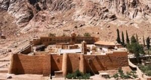
Tourism is a significant industry in Sinai
, with destinations like Sharm El Sheikh, Dahab, the Saint Catherine’s Monastery andMount Sinai attracting visitors from around the world. The Red Sea coast is particularly famous for its coral reefs, making it a popular spot for diving and snorkeling.
Despite its tourist appeal, Sinai faces challenges, including political instability and security concerns. The northern part of Sinai has been a hotspot for insurgency and terrorist activities.
The local population in Sinai: includes Bedouin tribes who have a unique culture and lifestyle, often living as nomadic herders. Their knowledge of the rugged terrain and traditional practices continue to be of cultural significance.
Efforts are ongoing to develop the infrastructure and improve the economic conditions in Sinai. Projects include road construction, urban development, and initiatives to boost tourism and agriculture.
Environmental preservation is also a concern, with several protected areas like the Ras Mohammed National Park established to conserve the region’s unique ecosystems.
In summary:: Sinai is a region of immense historical, cultural, and strategic importance, characterized by its diverse geography and rich natural resources. It faces both opportunities and challenges as it navigates the complexities of modern development and security issues.
If you willing to visit this holy land one day check this link here for more details and special offers.
Written by ATW updated July 2024


